Landmine detection and extraction robot
A mine-detection rover with a 6-DoF extraction arm, for a Lebanese Army initiative; I built its autonomy software.
My partSoftware lead: 3D LiDAR SLAM, Nav2, detection, the arm
In short
A tracked rover with a 6-DoF arm, built at RHU in 2024–2025 to find landmines and clear its own path. I led all of its software: 2D and then 3D LiDAR SLAM, navigation with Nav2, detection and segmentation from a camera, and the arm’s kinematics. We built it in two phases, indoors first and then outdoors with GNSS, and tested it in Mechref with the Lebanese Armed Forces.
- What it is
- A tracked rover with a 6-DoF arm that maps its surroundings, navigates on its own, and detects landmines, built as an RHU project for a Lebanese Army initiative.
- Why it matters
- Landmines and unexploded remnants still lie in parts of Lebanon, including near RHU’s campus in Mechref. Clearing them by hand is slow and dangerous; a robot has to know where it is, where it has searched, and what it is looking at, on rough ground and without a reliable map.
- My part
- I led all the software: the autonomy stack, navigation, SLAM, detection, segmentation, and the arm’s kinematics and inverse kinematics. It was an RHU project before I graduated, built with Wassim Ghaddar and the RHU Robotics and Technology Club team, guided by lab engineer Mohammad Al Kaderi, with field tests in Mechref alongside the Lebanese Armed Forces.
Step by step
- 1
Indoors, in 2D
A 2D LiDAR, wheel encoders, and an IMU, fused with LiDAR scan registration into 2D SLAM; Nav2 plans paths through the map and drives the rover. This was the prototype.
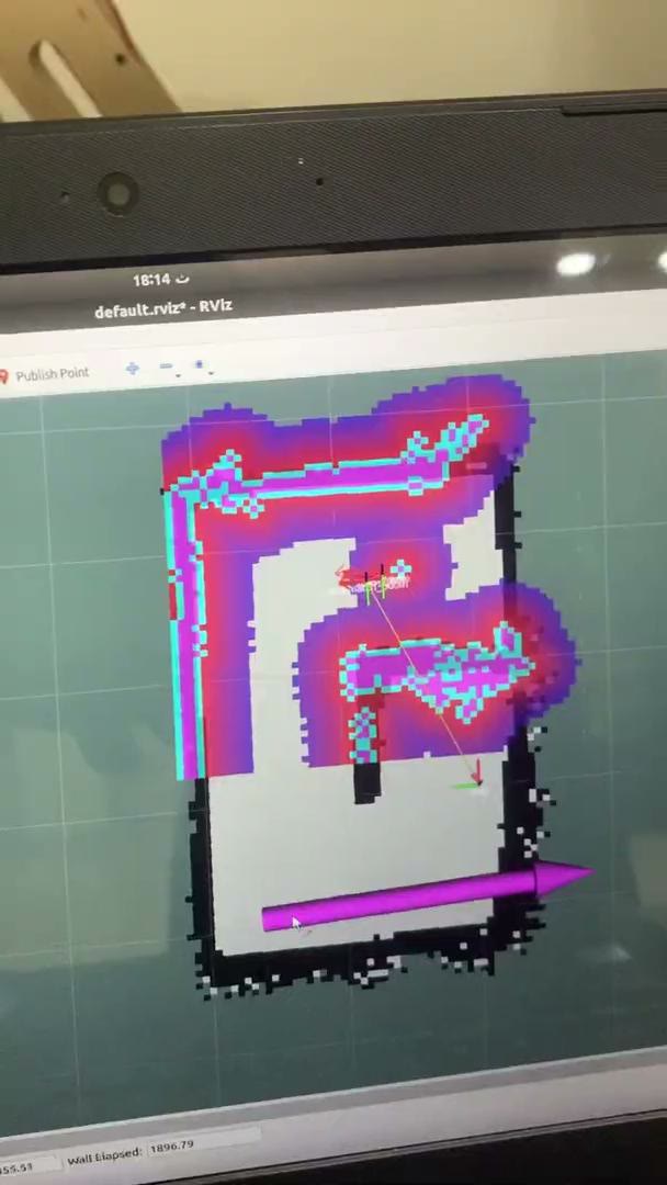
The indoor map in RViz: occupancy grid, inflated costmap, and the goal the planner drives to. - 2
Outdoors, in 3D
A 3D LiDAR and GNSS replace the indoor setup. SLAM fuses wheel odometry, the IMU, and GNSS, which corrects the map globally and gives each detected mine a position.
- 3
See
A camera runs segmentation and object detection, and its results feed the navigation; the LiDAR builds the 3D map.
The rover finds a stand-in target and stops in front of it. - 4
Reach
A 6-DoF arm, driven by kinematics and inverse kinematics I wrote, moves obstacles out of the path and shows that a mine could be handled.
The 6-DoF arm lifts an object out of the rover’s way. - 5
Field test
Small tests in Mechref with the Lebanese Armed Forces, using dummy mines.
Results
- 2
- Phases
- indoor 2D prototype, then outdoor 3D with GNSS
- Mechref
- Field tests
- with the Lebanese Armed Forces, dummy mines
- 3rd place
- DARE @ LAU
- April 2024, the first universities robotics competition
For engineersHow it is built, its limits, and its keywords.
How it works
Indoors, a 2D LiDAR, wheel encoders, and an IMU fuse into 2D SLAM, and Nav2 plans and drives. Outdoors, a 3D LiDAR and GNSS join the wheel odometry and IMU, with GNSS correcting the map globally so detected mines get real coordinates. A camera segments the scene and detects objects for navigation, and the 6-DoF arm moves obstacles out of the way and shows that a mine could be handled.
Limits
- The analysis panels are verified on simulated signals with known noise, vibration and distortion (the Noise Lab recovers the simulated white noise to within 1 %); long captures from the real unit are still to come.
- The outdoor tests were small, early trials with dummy mines; there are no quantified outdoor results yet.
- The arm is a proof of concept: it moves obstacles and shows how a mine could be handled, not a finished extraction tool.
Keywords
- ROS 2
- 3D LiDAR SLAM
- 2D SLAM
- Nav2
- GNSS
- sensor fusion
- landmine detection
- demining robot
- semantic segmentation
- inverse kinematics